Rainfall was below normal from July through September 21; the all-India cumulative rainfall touched the normal mark just last week.
Three days remain before the curtain falls on this year’s rains — the official end of the four-month southwest monsoon season. As of Monday, the country had received 850.3 mm of rain, 2% short of the season’s normal.
Wet, dry, very wet
Rainfall was below normal from July through September 21; the all-India cumulative rainfall touched the normal mark just last week. This was mainly due to deficient rain in Northwest (deficient from July 3 till date), and East and Northeast India (from July 7 till date). Rainfall over Central India turned normal last week after being deficient from July through September 15. Cumulative rainfall from June 1 to September 27 was –4 % in the Northwest, and –13% in East and Northeast India. In contrast, rainfall remained on the positive side in South peninsular India all through, and is 10% above normal currently. Central India has a surplus of 1%.
Rain in June was brought by the remnants of Cyclone Yaas, and by a near on-time onset of the monsoon over Kerala. It started to rain early across the Southern peninsula, and the East, Northeast and Central parts of India, and June closed with +9.6% for the country.

Belying IMD predictions, rainfall was poor in August, but there were extreme rain events in parts of Uttarakhand, Madhya Pradesh, Odisha, and Jharkhand.
The monsoon revived significantly in September, and so far, four low-pressure systems have brought rain over the highly deficient Central and Northwest regions. The first deep depression of the season dumped more than 400 mm of rain in 24 hours over Odisha, and another low-pressure system led to an almost equal amount of rainfall over Gujarat around September 13. Another low pressure system intensified to form Cyclone Gulab, which made its landfall on the coast of Andhra Pradesh and southern Odisha on Sunday.
Topsy-turvy patterns
Nagaland, Manipur, Mizoram, Tripura, among India’s wettest regions, recorded deficient rainfall for 17 consecutive weeks — the entire season — from June 2. Arunachal Pradesh saw a 14-week deficit, and Assam and Meghalaya, six weeks.
Kerala had 12 weeks of rainfall deficit, including 11 straight weeks from June 23 to September 1. Lakshadweep recorded 15 continuous weeks of deficient rain.
Odisha saw below normal rain for 10 straight weeks from July 7 to September 8. Gujarat and Saurashtra-Kutch had deficient rain for 12 and 11 straight weeks respectively.
The experience in Kerala confirmed the conclusions of studies that reported a declining trend over the Northeast and Kerala.
On the other hand, cumulative rainfall remained normal, in excess, or large excess for all 17 weeks over the meteorological subdivisions of Maharashtra, Bihar, East UP, Sikkim, Gangetic West Bengal, Chhattisgarh, Telangana, Rayalaseema, and Karnataka.
Uttarakhand, Jharkhand, coastal Andhra, Haryana, Delhi, and Chandigarh saw some deficiency during one or two of the 16 weeks.
A very dry August
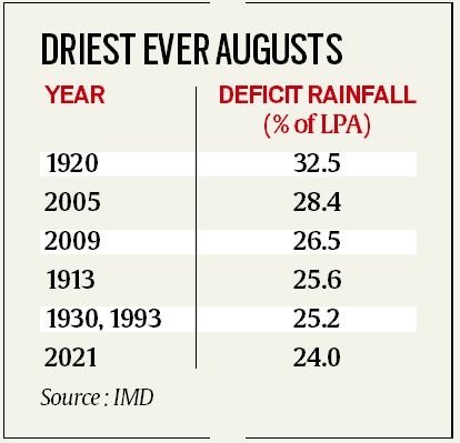
With rainfall in 24% deficit of the Long Period Average (LPA), this August was the sixth driest since 1901. Since 2009, only one other August has been drier.
Two dry spells lasted 18 days, and monsoon activity remained weak for three consecutive weeks from August 11-25. Several factors were responsible, the IMD said.
Fewer low-pressure systems: They are the main source of monsoon rainfall, and only two of these systems — instead of the normal four — developed over the Bay of Bengal this August. At least two of these systems normally intensify into depressions.
Position of monsoon trough: With no low-pressure systems forming, the monsoon trough remained to the north of its normal position for most days in August. As a result, rainfall was largely restricted to parts of Uttarakhand, Himachal, UP, and Bihar.
Western Pacific Typhoons: These usually bring good rain during August as they cross Myanmar. Their remnants then re-enter the Bay of Bengal, become fresh weather systems and approach the Indian mainland along the east coast. “This August, typhoon activity was far less, and hardly any of their remnants reached the Bay of Bengal. The typhoons that developed recurved north-eastward instead of advancing north-westward towards the Bay of Bengal. The absence of low-pressure systems brought less rain over Central India,” said D Sivanand Pai, head, Climate Research and Services, Pune.
Negative Indian Ocean Dipole: Since the start of the monsoon, the IOD has remained in its negative phase. Studies have linked the negative phase of IOD to below normal rainfall. ? Express Explained is now on Telegram. Click here to join our channel (@ieexplained) and stay updated with the latest
Off-shore trough: An off-shore trough that generally runs between Gujarat and Kerala, attracts moist winds from the Arabian Sea towards land, causing heavy rain in Gujarat and coastal Maharashtra, Goa, Karnataka, Kerala. This off-shore trough was largely absent last month. Without the off-shore trough, south-westerly monsoon winds that bring heavy rain over the west coast, remained significantly weak.
Madden Julian Oscillation : This eastward-moving pulse of clouds brings rainfall along the Equator during a 30-60-day cycle. In August, these waves were prevailing near Africa, thus not helping cloud formation over India.
Pouring, persistent
The normal date for commencement of withdrawal is September 17; this year, it is not expected to start withdrawing before October 6, as per the IMD’s Extended Range Forecast. That would make 2021 the year of the second most delayed retreat of the monsoon since 1975. In 2019, the monsoon started to withdraw on October 9.
The country has so far recorded 205.4 mm rain in September, 29.3% surplus. With more rain forecast from the remnants of Cyclone Gulab over the next three days, the monsoon could end up in the normal category.
Source: Read Full Article


