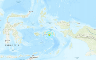
The U.S. Geological Survey said the earthquake was centred about 10km under the sea 70km from Amahai city on Seram island in Maluku province.
A 5.8 magnitude earthquake under the sea shook part of eastern Indonesia on Wednesday, and residents on the beachfront in part of Maluku province were told to go to higher ground.
Indonesia’s Meteorology, Climatology and Geophysics Agency said people along Japutih and Apiahu beaches in Central Maluku district should immediately leave the beach area and should beware of aftershocks and potential tsunamis due to the undersea landslides.
The U.S. Geological Survey said the earthquake was centred about 10km (6 miles) under the sea 70km (43 miles) from Amahai city on Seram island in Maluku province.
Indonesia, a vast archipelago of 260 million people, is frequently struck by earthquakes, volcanic eruptions and tsunamis because of its location on the “Ring of Fire,” an arc of volcanoes and fault lines in the Pacific Basin.
Source: Read Full Article

